Iron Steeds on the Pakihi
A pioneering ride of a popular mountain bike trail
Written for Adventure magazine in the 1990s
In the early 1990s I became fully involved into the concept of adventure tourism. I was the associate editor of New Zealand Adventure magazine and, together with publisher John Woods, we embarked on an exciting mission to package and promote the concept of adventure travel in New Zealand. One of the emerging adventure pursuits around this time was mountain biking. John and I teamed up with a variety of mountain biking pioneers and rode and wrote about a number of off-road cycling adventures, including this story I put together when a group of newly-minted MTB fanatics decided to ride the Pakihi Track in the Motu area north of Gisborne. First opened around 1906 as part of a rough stock trail connecting Motu to Opotiki via the Otara Valley, the Pakihi Track is today a popular 20km mountain biking and hiking trek, with bridges across the Pakihi River and formed trails making the route so much safer than it was back when we were the second-group-ever to ride the Pakihi. At that time the Department of Conservation's East Coast Conservancy was preparing a plan to establish the Pakihi Track as a trial mountain bike cycling journey and our journey was part of the initial research for the concept.

Riding the Pakihi Track in the early 1990s was a downriver carry for much of the route through the tight gorges and bends of the Pakiri River.
These days bicycles are going places the Man From Snowy River would baulk at urging his horse. If a mountain biker is prepared to carry his steed over stretches of unrideable terrain, there is almost nowhere a determined off-road explorer can't go.
In the bush-country between the southern Bay of Plenty and Poverty Bay there's a track being developed as the region's first ever cycling opportunity through a wilderness area administered by the Department of Conservation.
The Pakihi Track is a breathtaking single-track experience through pristine native bush. It's a five-hour adventure cycling journey which drops off the already remote Old Motu Coach Road all the way to Opotiki via a disused turn-of-the-century stock route.
Much of the journey at this stage involves walking, including a back-breaking two-hour hump down an incredibly rugged, and beautiful, river gorge—crossing and recrossing the knee-deep river hundreds of times.
Shortly before Queen's Birthday this year, the track was ridden and walked from end to end for the first time. A team of four including Opotiki adventure tour operator Tim de Jong and Department of Conservation (DoC) information officer Mark Baker made a pioneering excursion to evaluate the route.
A morning coffee discussion at the Adventure magazine office a week later soon saw plans being laid for a second mission. So it wasn't long before a team of ten gathered at Matawai on a particularly cold, early-September Saturday morning.
Tim de Jong of the Dreamers and East-Capers cycle tour operation laid on the transport to the start of the track, high up on the Old Motu Coach Road. Mark Baker was there again with a varied selection of Opotiki and Gisborne off-road biking enthusiasts.
The first few kilometres on the Motu Road were a good chance to warm up. It's rolling country, with views all the way to Whale Island in the Bay of Plenty. The road is high enough that we could look straight across at the rocky spine of the Raukmara Ranges to our northwest.
Having a bike mechanic in the crew soon paid off with Gavin Hill from Frank Allen Cycles patching up a dodgy-looking entry-level machine within the first few minutes.
Entering the Pakihi, marked by a DoC route sign, was like entering a dank, fragrant closet. The dense tree canopy screening out most of the bright daylight. Everyone was soon grinning from ear to ear—this was real off-road cycling following a single-track with a perceptible downhill trend, winding around the gullies of a major ridge. Underneath was a soft mulchy track, booby-trapped with familiar Waioeka rock, crumbly and sharp enough to puncture a tyre. It was slimy and slippery at times, firm and loamy at others.

This was just one of the dozens of river crossings on the Pakihi that have since been replaced by bridges.
The bush reached out at us. Ferns, mountain cabbage, kiekie and many other native species brushed our shoulders as we passed. The silence was broken only by the occasional squeal of brakes or rattle of dislodged rock.
Small creeks and cataracts dissected the track, some rideable but many forcing us to dismount. Occasionally, huge fallen trees blocked the track reminding us that this is a very remote area. We were aware that we were responsible for our own survival here. A fall or crash which damaged cycle or rider could easily mean we become the subject of one of those TVNZ search and rescue stories on the evening news.
The falls came thick and fast. They were amusing, but we were conscious of the risk of life-threatening tumbles hundreds of metres into the gorge below. It was easy to momentarily lose concentration and a couple of serious crashes were only avoided by riders grasping desperately at trees to avoid plunging off the trail.

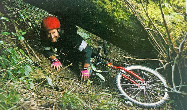
Our riders negotiate the tricky bench track that was the Pakihi Trail in the early 1990s. This was just the second time the route had been negotiated by bicycle.
Cycling on, we reached a point where the track changes character, traversing a northern face of the ridge and becoming more overgrown. This marks the limit of work done by DoC and volunteers from Saint Peter's School near Cambridge. The St. Peter's students, mostly fourth formers, visit the area each year to work on huts and tracks for DoC. In return, they receive outdoors and bushcraft instruction and enjo a break from their studies.
On the northern faces, clearings were filled with a dazzling seas of grass, back lit by the sun. Jackets were shrugged off. Steam rose off hot bodies. There was a feeling of expectancy here, even though the conditions on the trail had turned quite poor for cycling.
There were many logs across the track, and dismounting became a regular duty. Once, we needed to push our bikes underneath a mammoth-sized fallen tree too big to climb over. We could hear the invisible stream rushing through the bush-filled valley beneath us.
It was hard going but this section of the track will be cleared and re-benched before the Pakihi is officially open for cycle use.
Tim de Jong takes the only route through an obstacle created by a giant fallen tree across the Pakihi Track.
We had been on the track for over an hour and still the trend was downhill. It was deceptively easy riding at times, although the later sections of the ride are certainly not for the novice or the unfit. Then, unexpectedly, we arrived at a huge slip which marked the end of the first section of the ride.
We carefully portaged the cycles across this, looking down to the river way below. Then followed a further brief cycle to finally reach the outer end of the ridge and after a steep descending zig-zag we arrived at the Pakihi Hut and a welcome stop for lunch.
The Pakihi Hut is a category four, which means DoC doesn't charge for overnight stays. It also means the facilities are fairly basic; a set of bunks, a corrugated iron fireplace and a meat safe. There's a rubbish pit at the hut, but the East Coast Conservancy is following national directives, moving to a "pack it in, pack it out" policy. We tuck our banana skins and muesli bar wrappers in our bumbags.
From the hut, it was down to the Pakihi Stream bed to begin the arduous portage. The track alongside the stream was wiped out in Cyclone Bola, and some serious regrowth has taken place in the intervening years. As any bush user knows, the most direct route down a river involves multiple crossings. Our feet were soon numb with cold.
Our expedition stretched out for half a kilometre as we march silently in single-file down the narrow gorge alternately shaded and sunlit with each bend. The carry continued for nearly two hours.
While this section will ultimately be re-established along the river's banks before the track is officially re-opened, our group relished the wilderness challenge of the walk. Despite aching shoulders, many in our expedition commented that the walk was a memorable bush experience.
Just as some started re-evaluating this sentiment we reached signs of the original track above the river becoming more established. We climbed up through dense bush to find short sections of the route were rideable, and we were away again. Our pace increased, as the track cleared even when "wall-of-deathing" across narrow washed-out sections 20 metres above the river bed. Just as the first chills of evening were becoming persistent, the track opened out to full benched width. Flat and level, it wound on out of the gorge into scrubby farmland.
We passed by a swingbridge across the river and rode out to the head of the Otara River Valley Road and the northern end of the Pakihi Track. From here we rode a fast five kilometres warm-down along a wide dirt road to meet the waiting transport van. It was still a long drive into Opotiki, and another hour or more back through the Waioeka Gorge to Matawai to reconnect with our own transportation for the last 100km drive back to Gisborne and home.
It's a special place, the Pakihi. Riding it for recreation we could only wonder at the pioneer settlers who used it as a stock route, bringing cattle through the almost impassable ranges which separate Gisborne and Opotiki. What would they have thought of these city folk on bicycles who made the same journey just for fun.